

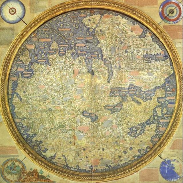
На другому поверсі бібліотеки Святого Марка у Венеції цілу кімнату займає єдина мапа – і виправдано, враховуючи її історичне значення та розміри (2,4 м x 2,4 м). Це – Mappa Mundi (у перекладі – “мапа світу”), завершена в 1459 році, яка зібрала в собі всі географічні знання того часу і вважається найкращою середньовічною мапою.
Майже вдвічі більша за знамениту англійську Герефордську мапу світу (бл. 1300 р.), ця вишукано декорована планісфера, що зображує Європу, Африку та Азію – шедевр Фра Мауро, ченця камальдольського ордену, який жив на маленькому венеціанському острові Сан-Мікеле.
Хоча нога ченця ніколи не ступала за межі Венеції, його Mappa Mundi дивовижно точно зображує міста, провінції, континенти, річки та гори.
На мапі немає Америки – оскільки Христофор Колумб здійснив свою подорож через океан лише 33 роки потому – а також Австралії. Але є Японія (або, як називає її Фра Мауро, Cipango) – і це перше її зображення на західній мапі. І чи не найбільше вражає те, що Африка зображена в оточенні води з усіх боків – задовго до того, як португальці обігнули мис Доброї надії в 1488 році.
“Це найстаріша середньовічна мапа, яка збереглася”, – каже Мередіт Франческа Смолл, авторка книги “Тут починається Темне море”, і додає, що вона також є й найповнішою.
“Це перша мапа, яка більше базується на науці, ніж на релігії. Герефордська мапа – це пропаганда, релігійна пропаганда”, – вважає науковиця.
Герефордська зображувала рай і пекло. Вона створена як збірник світових знань з духовної точки зору, натомість Фра Мауро застосував науковий підхід до своєї картографії. У своїх записах він твердив, що “перевірив текст практичним досвідом, досліджуючи протягом багатьох років і відвідуючи осіб, гідних віри, які бачили на власні очі те, про що я тут сумлінно повідомляю”.
Однак мапа має не тільки наукове та історичне значення. Що найбільше у ній вражає та одразу впадає в очі після підйому білими мармуровими сходами Бібліотеки Святого Марка, де зберігаються найцінніші й найдавніші рукописи світу, так це її велич та вишуканість.
“Вона величезна, красива, фантастично зроблена”, – каже історик П’єральвіз Зорзі.
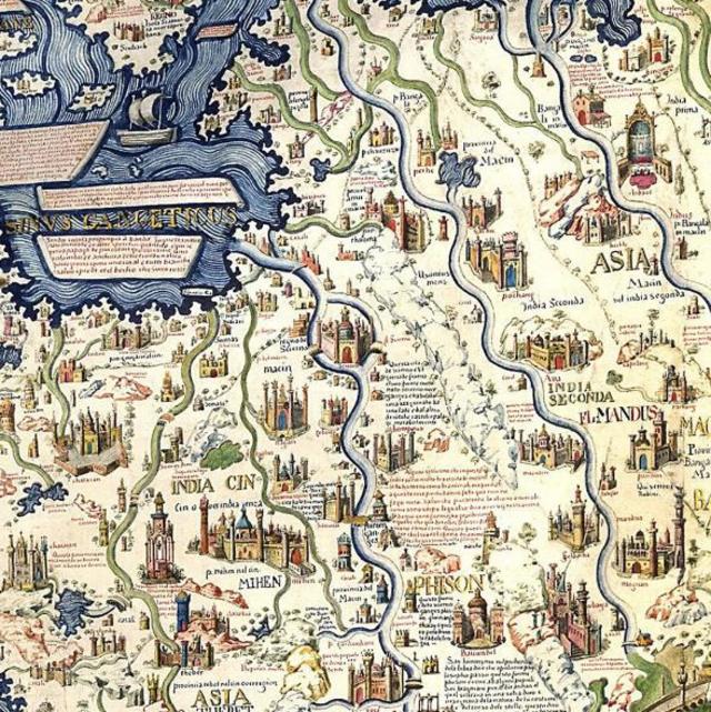
Mappa Mundi Фра Мауро – це не просто контури країн і континентів, це чудова золотаво-блакитна картина, що містить дрібні малюнки розкішних палаців, мостів, кораблів, синіх хвиль, що перекочуються, і величезних морських істот, а також загалом 3000 cartigli – червоних і синіх анотації, написаних давньою венеціанською мовою, які розповідають історії, анекдоти та легенди.
У Норвегії, наприклад, такий напис супроводжує місце, де венеціанський купець П’єтро Керіні зійшов на берег після корабельної аварії. Згідно з легендою, він не тільки вижив у результаті аварії, але й привіз додому сушену рибу, таким чином поклавши початок венеціанській пристрасті до страви “баккала”.
АВТОР ФОТО,BILDAGENTUR-ONLINE/GETTY IMAGES
Інший напис вказує на Тарс – “царство, звідки прийшли волхви” – яке, як тоді вважали, було десь між Китаєм і Монголією.
Усі ці анотації розбірливо нанесені на мапі, і їх відносно легко розшифрувати носіям венеціанської мови, оскільки нинішній діалект не сильно відрізняється від мови 15-го століття.
Ці написи також переклали англійською мовою на інтерактивній мапі, яку створив Інститут і музей Галілея у Флоренції. Її демонструють на екрані в тому самому виставковому просторі, що й Mappa Mundi, і вона дає можливість поглянути на світ очима середньовічного ченця.
І це був не маленький світ. Хоча Фра Мауро прожив усе своє життя у монастирі на острові в затоці, він використовував знання мандрівників і торговців, які стікалися до квітучої Венеції, яка була “столицею картографії того часу”, пояснює Маргарита Вентуреллі, працівниця бібліотеки Святого Марка.
“Мапи були ключовими для торгівлі, тому що якщо у вас є хороша мапа, ви можете поїхати всюди, – додає Зорзі. – У Венеції вітали кожне нововведення у сфері картографії і добре його оплачували”.
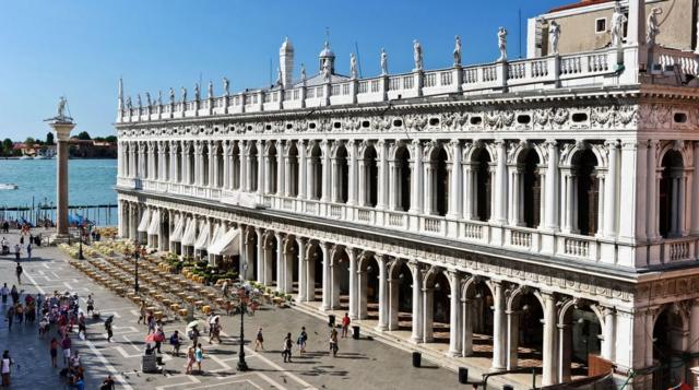
АВТОР ФОТО,MO PEERBACUS/ALAMY Підпис до фото, Бібліотека Святого Марка має одну з найбільших у світі колекцій класичних текстів
Основним джерелом інформації щодо Азії для Фра Мауро був купець і його співвітчизник, венеціанець Марко Поло, який опублікував свої подорожі за 150 років до того.
150 місць на мапі можна безпосередньо співвіднести з його подорожами. Наприклад, на острові Цейлон (нинішня Шрі-Ланка) гора Адама, де, згідно з легендами, переказаними Поло, поховано тіло першої людини – разом із його зубами та мискою, яка нібито мала магічну властивість примножувати їжу.
Окрім Поло, Фра Мауро мав численні інші джерела по всьому світу. Той факт, що карта для сучасних західних очей виглядає перевернутою, з півднем угорі, може вказувати на те, що він черпав натхнення у арабській картографії, зокрема мапі 12-го століття північноафриканського географа Мухаммада аль-Ідрісі.
Числа, які Фра Мауро називає “відстанню небес”, походять від математика й астронома Кампануса де Новара. “Від центру світу до поверхні Землі 3245 миль. Від центру світу до нижньої поверхні небес Місяця – 107 936 миль” тощо, пише він у верхньому лівому кутку Mappa Mundi.
Фра Мауро також виявляв здоровий скептицизм і не соромився критикувати – але іноді й використовувати – шановану “Географію” Птолемея, яку написав у Александрії в Єгипті Клавдій Птолемей у 150 році нашої ери. Цей твір для західного світу був втрачений протягом століть, поки у 1400-х роках його не відкрили заново й не переклали латиною.
АВТОР ФОТО,THE HISTORY COLLECTION/ALAMY
Раціоналістичний підхід епохи Відродження також виявився у тому, як він розмістив Адама і Єву в Едемському саду за межами планісфери, даючи зрозуміти, що небо – це не місце на землі. Такий погляд розділяв релігію та географію і був прогресивним для будь-якої середньовічної людини, не кажучи вже про ченця.
Усі ці новації та той факт, що мапа була завершена за кілька десятиліть до того, як Христофор Колумб відплив до Америки, сприяють тому, що Mappa Mundi Фра Мауро вважають географічним зв’язком між Середньовіччям і Відродженням.
Сучасним же відвідувачам мапа є нагадуванням про те, що колись карти були не лише практичними інструментами, а й витвором мистецтва – і способом розповідати найнезвичайніші історії.